A Note on Neighborhoods

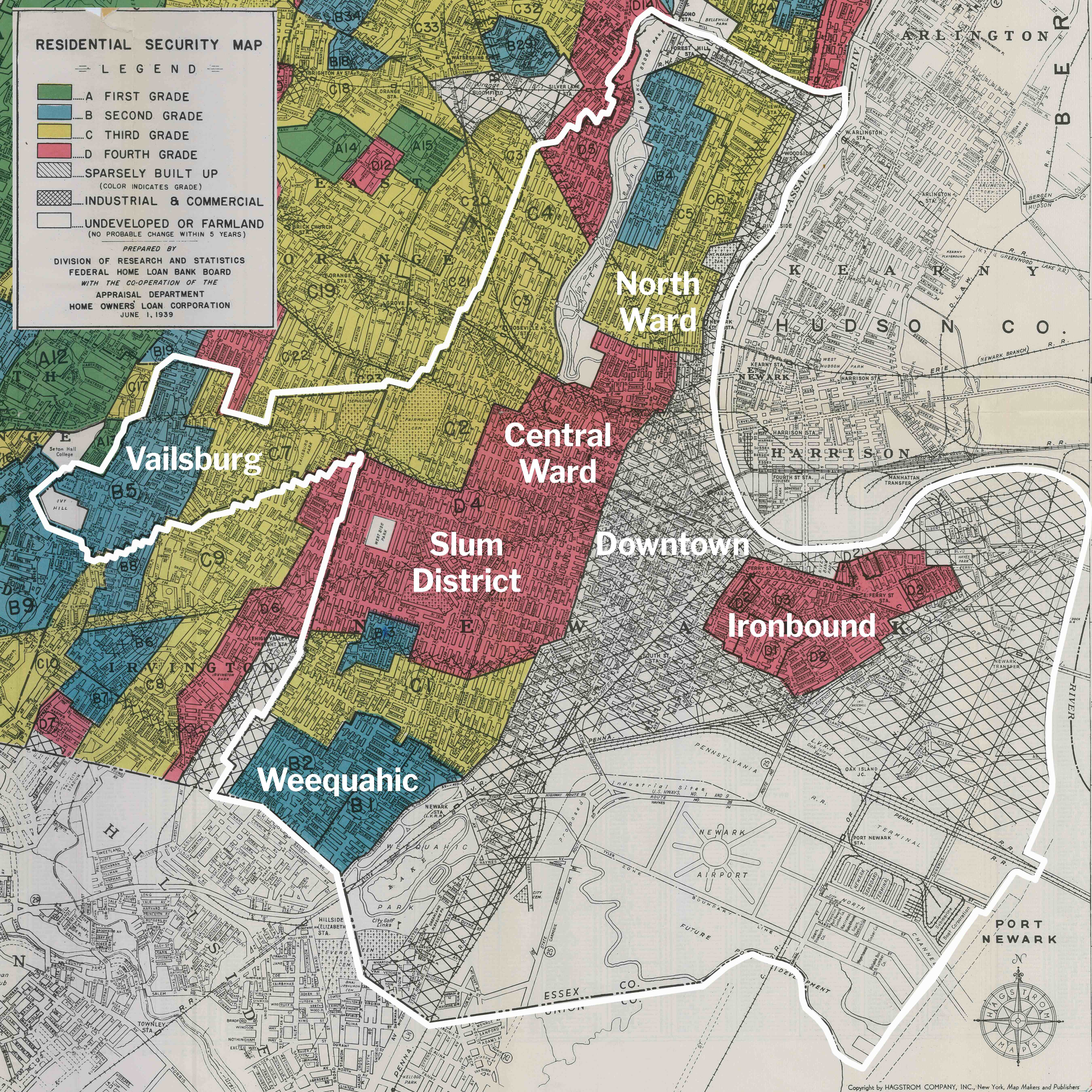
The majority of Dr. Berg’s photos document the 2.5 square mile area of Newark bounded by Interstate 280 to the north, Bergen Street to the west, Clinton Avenue to the south, and the Passaic River / Route 21 to the east. In the period 1950 to 2020, over 90% of all homes were cleared in this area home to almost 100,000 people in the 1940s. Roseville lost to build Interstate 78 and Weequahic lost to build Interstate 280 were also documented. Only a few of his photos document other neighborhoods. See map:

For more old photos of other Newark neighborhoods, visit the Digital Collections of the Newark Public Library online or contact library staff to visit in person.

Also visit the partner project Newark Metamorphosis that presents an interactive map of 350 postcard comparisons of Newark in 1916 vs. 2016.

What is the invisible city?


At a cost of $40 million, 469 structures were demolished to displace 4,600 people in Newark’s Little Italy of the Old First Ward. This panoramic photos shows the extent of demolition by December 1, 1953. Caption: “First Ward area takes on tornado-tossed appearance as demolition proceeds. View south from 8th avenue with High street at left.”

Italo Calvino describes the city of Maurilia in his 1972 novel Invisible Cities. The book is a collection of paragraph-length descriptions of 55 imaginary cities drawn from across space and time. Here is one chapter, with each mention of Maurilia replaced with Newark.

In [Newark], the traveler is invited to visit the city and, at the same time, to examine some old postcards that show it as it used to be: the same identical square with a hen in the place of the bus station, a bandstand in the place of the overpass, two young ladies with white parasols in the place of the munitions factory. If the traveler does not wish to disappoint the inhabitants, he must praise the postcard city and prefer it to the present one, though he must be careful to contain his regret at the changes within definite limits; admitting that the magnificence and prosperity of the metropolis [Newark], when compared to the old, provincial [Newark], cannot compensate for a certain lost grace, which, however, can be appreciated only now in the old postcards, whereas before, when that provincial [Newark] was before one’s eyes, one saw absolutely nothing graceful and would see it even less today, if [Newark] had remained unchanged; and in any case the metropolis has the added attraction that, through what it has become, one can look back with nostalgia at what it was.

Beware of saying to them that sometimes different cities follow one another on the same site and under the same name, born and dying without knowing one another, without communication among themselves. At time even the names of the inhabitants remain the same, and their voices’ accent, and also the features of the faces; but the gods who live beneath names and above places have gone off without a word and outsiders have settled in their place. It is pointless to ask whether the new ones are better or worse than the old, since there is no connection between them, just as the old post cards do not depict [Newark] as it was, but a different city which, by chance, was called [Newark], like this one.

Source: pages 30-31

Wiss Building, W side Littleton between West Market & 11th Ave on July 2, 1969

D​amon Pressman writes:
“I’ve been doing research on Newark, specifically from about 1909-1923. My great-great grandfather apparently had a luggage factory at the corner of Seventh and Summer Streets. He was Max Naidis, and the M. Naidis Trunk & Bag company operated there during this time. It’s an empty lot now​.​”

#56 & 60 Roseville Ave on April 22, 1962

Dan O’Flaherty writes:
“From the left, Richie and Ronnie Giuliano lived on the second floor (I think) of the 3-decker. They were older than us but we played with them. They were cousins of the two Anthony Giuliano’s who were city councilmen at large in the 60s and 70s. Patsy Madera, about their age, was on the third floor. Her father Al )Eldo) Madera, was an inspector for the City. My parents knew him and I got to know him in the 80s. The next house, the 2-story, was where the Gibbons brothers practiced dentistry and where we went for dentist visits. You can see a sliver of our house, 62 Roseville on the far right. Pig Tail Alley ran behind all these houses.”

Aerial views from roof of City Hospital show entire neighborhoods cleared for the campus of UMDNJ.

The Belmont neighborhood on June 18, 1961

Looking down southeast from 10th floor Martland

.

And the identical view on September 24, 1967


Looking east from roof City Hospital, leveled area Cabinet Street (left) to 12th Avenue (right), Bergen St (foreground) to Morris Avenue (distance)
.

The Belmont neighborhood on June 18, 1961

Looking down northeast from 10th floor Martland

.

And two identical views on September 24, 1967


Looking northeast from roof City Hospital, leveled area Hunterdon Street (foreground) to Bruce Street (distance, West Market Street (left) to Cabinet Street (right)
.

Looking northeast from roof City Hospital, leveled area Bergen Street (foreground) to Morris Avenue (distance), West Market Street (left) to Cabinet Street (right)
.

Further demolition in 1967 for UMDNJ


Looking northeast from City Hospital
.

Looking down southeast from 10th floor Martland
.

Looking down southeast from 10th floor Martland
.

Looking west from roof City Hospital, Fairmount Avenue (foreground) between 12th Ave (left) and Cabinet (right)
.

Fairmount Ave (foreground), Cabinet Street (lower left), Wiss Factory (center distance), West Market (upper right)