
![]()
Travelers' Map is loading...
If you see this after your page is loaded completely, leafletJS files are missing.
If you see this after your page is loaded completely, leafletJS files are missing.
![]()
The flowering of the American city was short and came to a quick end. America was never an urban nation, at least it did not think of itself as urban for most of its history. But for a brief few decades between the end of the U.S. Civil War and end of the First World War, the American downtown prospered. Department stores, factories, banks, insurance companies, and the homes of wealthy and poor people alike were all clustered around the American downtown. Downtown was the center, first of people, then of industry, and then of the cultural institutions built by public funds and industrialists’ donated wealth: public libraries, public museums, and public parks.
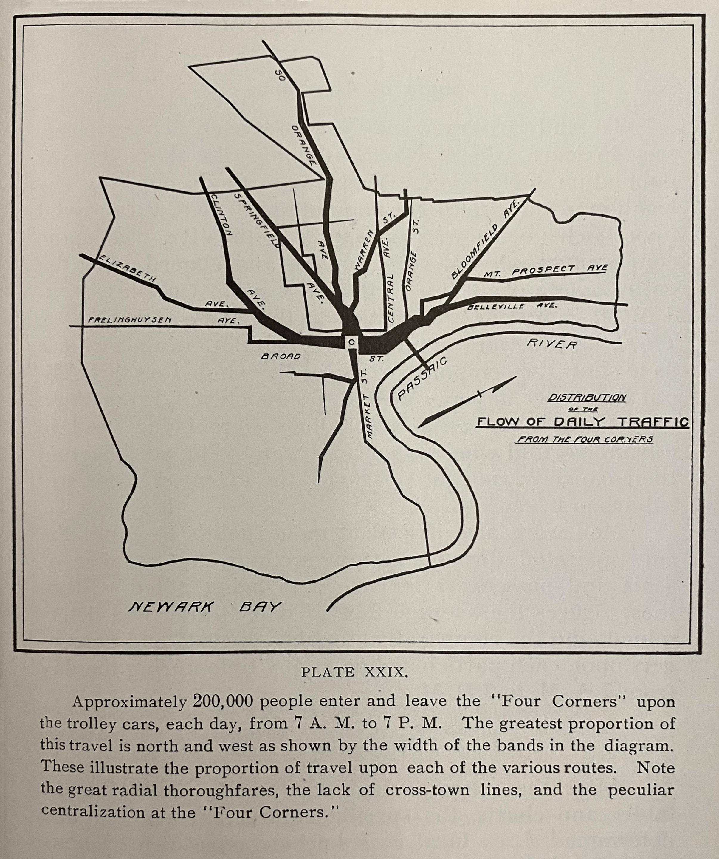
1913 map by Harland Bartholomew
All streetcar traffic converged on Broad and Market, as shown on the map above. Stretching out from downtown like legs on a spider was the web of radial streets and streetcar tracks. Five miles from downtown Newark and ten miles from Lower Manhattan, the city came to an end wherever the streetcar lines stopped. In Newark, streetcars extended north and south on Broad Street, northwest on Bloomfield Avenue, west on Market Street, and southwest on Springfield Avenue. A few miles distant, where land was cheapest, the streetcar lines ended with their maintenance yards and storage sheds adjacent the city cemeteries. In an age before the automobile, the size of the American city was limited by the size of its commuter transport system on horse cars, trolleys, railroads, and omnibuses.
Consider this 1916 description of downtown Newark glowing with life, written by literary critic Walter Prichard Eaton on the occasion of the 250th anniversary of Newark’s founding:
The colors leap out from the women’s hats and dresses, and faces flash white. Flags high aloft and the myriad shop windows along the curb supply additional color, while in Newark especially the big orange-yellow trolley cars, moving slowly along the centre of the way, keep the color note prominent. It is this bright, animated stream of life, in ceaseless motion, now black with shadow, now flashing into color, forever pouring through the bottom of a cañon which displays the shifting lights and shades of Nature’s handiwork together with flags and glittering window-panes and gilded signs of man’s making, that constitutes the peculiar feature of American commercial cities.
All traffic and all people went through downtown. There were no highways the way there are today – like Route 21, Interstate 78, and Interstate 280 – for high-speed traffic to bypass downtown. By the time Newark’s Public Service Trolley Terminal opened at Military Park in 1916, 300 trolleys an hour passed through the adjacent intersection of Broad and Market Street. The map below from planner Harland Bartholomew illustrates that as late as 1934, up to 300 buses and trolleys each morning rush hour delivered passengers to downtown offices and department stories. Notice on the below map that the width of colored lines indicates the intensity of traffic, and that all traffic converges on downtown. Both local commuter traffic, trolleys, buses, and long-distance truck traffic shared the same roads.

1937 map by Harland Bartholomew, source
Suburban sprawl and interstate highways changed all this. By 1910, one out of ten New Jersey residents lived in Newark, and about one half of all New Jersey residents lived within a 45-minute commuting distance of downtown Newark by public transit. One quarter of all jobs were in Newark, and one half of all department store purchases were in Newark. the 1940s and 1950s, all this began to change. The map below from a later master plan shows the majority of traffic bypassing downtown along the interstate highways.

1937 map by Harland Bartholomew, source
At the same time suburban sprawl and White flight pulled people away from Newark. Newark’s population fell, both in real numbers and as percentage of New Jersey’s population. In 1910, 14% of all New Jersey residents lived in Newark. By 2010, only 3% of New Jersey residents lived in Newark. The table below compares population growth in Newark vs. New Jersey. While the state of New Jersey and Newark suburbs kept on growing, the population of Newark stagnated and declined.

The quality of downtown life and the quality of the urban form suffered. As downtown lost population, it evolved from a mixed-use residential, industrial, and commercial neighborhood. By the 1970s and 1980s when Gateway Center was completed, downtown had completed its transformation to become a commercial neighborhood, active during the workday but inactive and dead at night. In lock step with downtown’s loss of population, the old fabric of downtown’s homes and businesses were demolished and replaced by upwards of 300 acres of surface parking and hundreds more acres of urban renewal projects.
A city that was 97% White in 1910 had become over 50% Black by the 1960s. As Blacks grew as a percentage of Newark’s population, downtown businesses continued shifting their investments away from the Black inner city. Newark’s Prudential insurance company rebuilt its downtown offices in the 1960s but opened branch headquarters in the suburbs. Newark’s Bamberger’s department store expanded to branch locations in suburban shopping malls. Newark’s Howard Savings Bank opened branch banks, first on the highways that cut through Newark and later in the suburbs themselves. While businesses moved away, factories simply closed up shop in the 1980s onwards and moved abroad for cheaper foreign labor.
In the essay In the essay Voices of Newark, journalist Jervis Anderson described downtown in October 1967, just weeks after the July 1967 rebellion:
The stranger from Manhattan enters and leaves at downtown Newark. The impression, on leaving, is what it was on entering: sterility, a dingy collection of commercial buildings with a stunted air over them, spreading away in a monotonously flat expanse. Nowhere is there to be seen that leap skyward that nourishes and releases the imagination. The Cultural Center on Broad Street, probably the place where the fashionable used to repair for a leisurely musical evening, now stands in jaded baroque among a row of modest storefronts, looking like an early affluent mistake. There are many Negro faces mixed in the crowds downtown, but they all seem like visitors’ faces, wearing a look of connection to some other turf. A cop roars off from a traffic intersection on a powerful motorbike; his eyes are hidden behind broad, metal-rimmed dark glasses, and his blue shortsleeves are rolled up above his biceps. He leaves behind a fleeting hint of what one has heard and read of Southern small-town terror.
Nor does it help that one’s first look at the city comes on a hot midsummer’s day: in this stifling and oppressive embrace, one imagines that Newark could easily be a place where nothing grows, where tender shoots sprout and then wilt. It makes one wonder a little about what will become of all the tender black dreams, both those that are radically new and those old ones that keep sprouting over and over again through the dead ground.
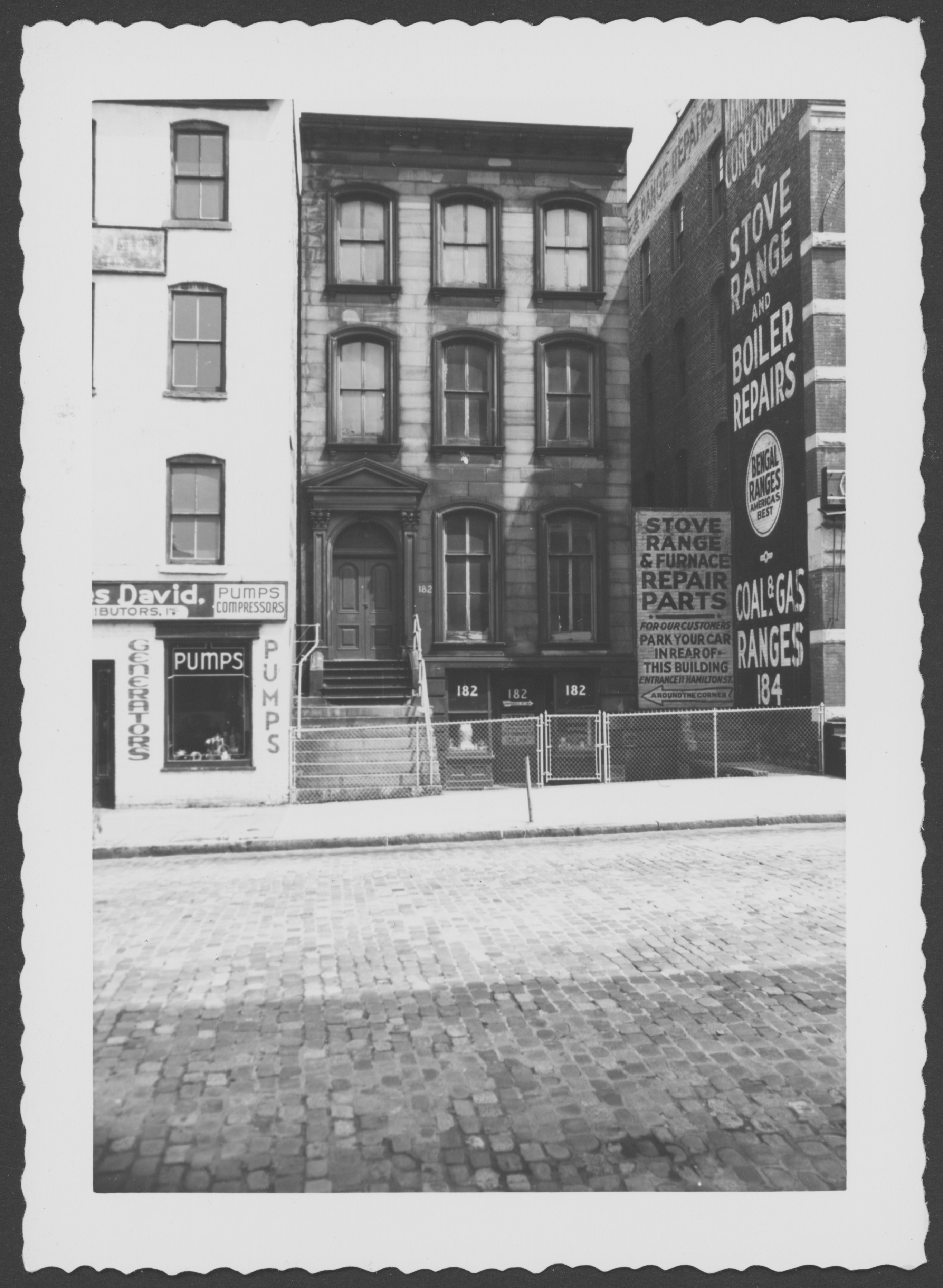
As you view these photos of downtown, reflect on how the city has changed over time and how the visually unpleasant parts of Downtown were not always this way. Consider: What kinds of buildings and living spaces could bring back people to live downtown, within walking distance of the places they work? What kinds of government policies could reverse the suburban sprawl and bring back business investment to Downtown? The history of where Downtown was in 1910 must be the inspiration for how the Downtown will be rebuilt. The city must be rebuilt not with skyscrapers and superblocks but with the kinds of human scale and walkable streets of multi-use small buildings that the city once had.

Robert Singer writes:
“My father owned a business around the corner from here on Market Street. I used to shop here on Mulberry Street when I was a teenager. As you rounded the corner from Market to Mulberry, the street was full of old industries, bargain shops, and the like. All of it is long since gone.”
Map of Downtown Newark in 1873 vs. 2016

January 1959
Old First Cemetery looking NW from far rear

July 1961
Park lot graveyard Old First Ch. looking NW from Central Railroad Depot

March 1962
Park lot rear Old First church, formerly graveyard

The same location today
The cemetery is now beneath the playing field of the Hockey Arena
The same location today

The same location today
A change in urban form and urban scale

Old First Cemetery looking SW from Central RR Depot

Old First Cemetery showing a mound at SW corner

Old First Cemetery showing steps to be excavated, a mound at SW corner

Old First Cemetery looking NW from Central RR Depot


Search by street name, not address

