Travelers' Map is loading...
If you see this after your page is loaded completely, leafletJS files are missing.
If you see this after your page is loaded completely, leafletJS files are missing.
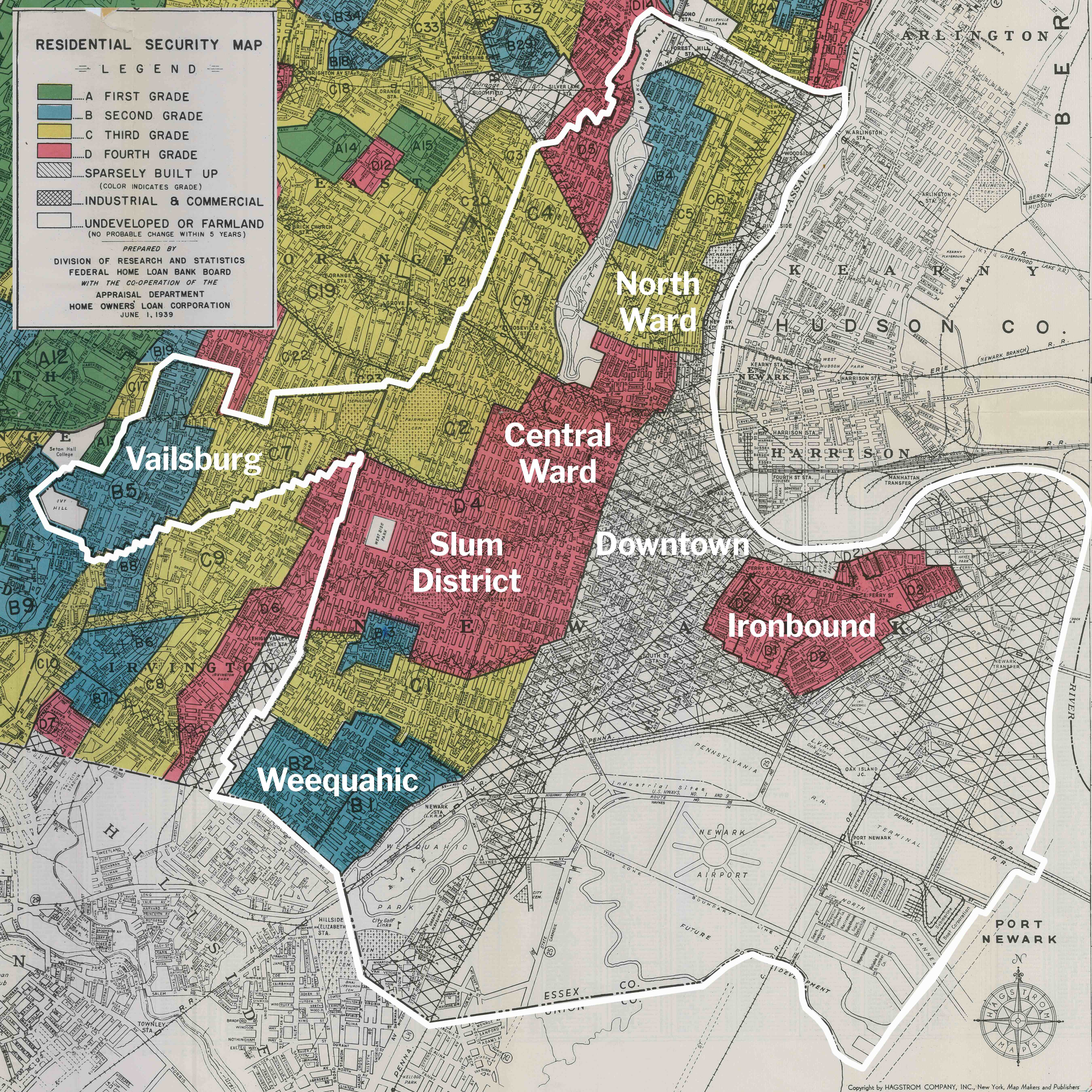
The flowering of the American city was short and came to a quick end. America was never an urban nation, at least it did not think of itself as urban for most of its history. But for a brief few decades between the end of the U.S. Civil War and end of the First World War, the American downtown prospered. Department stores, factories, banks, insurance companies, and the homes of wealthy and poor people alike were all clustered around the American downtown. Downtown was the center, first of people, then of industry, and then of the cultural institutions built by public funds and industrialists’ donated wealth: public libraries, public museums, and public parks.
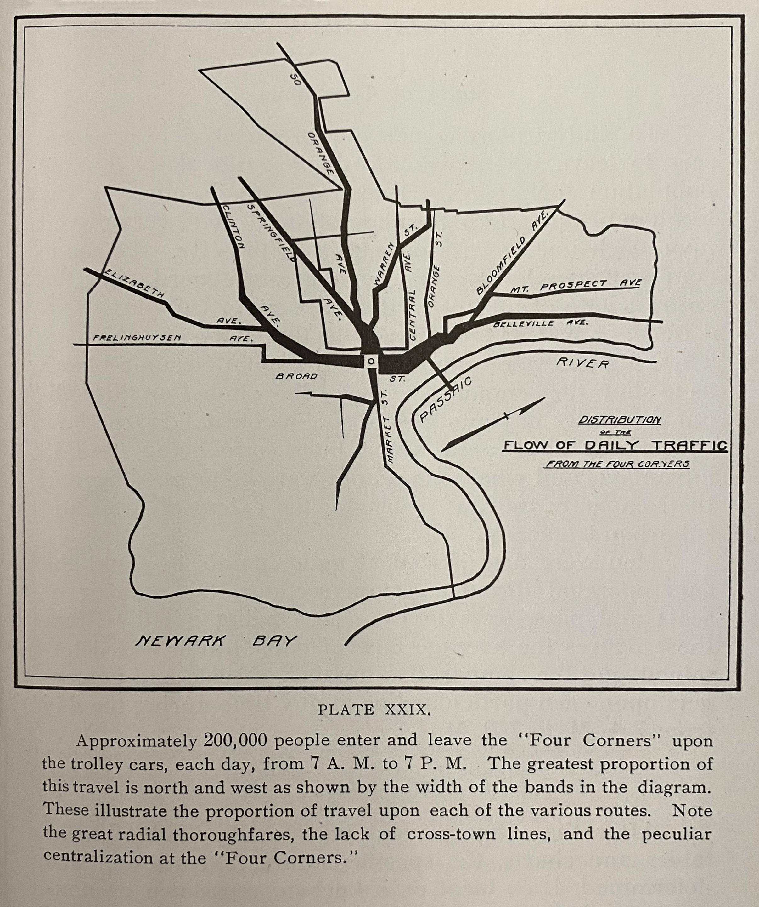
1913 map by Harland Bartholomew
All streetcar traffic converged on Broad and Market, as shown on the map above. Stretching out from downtown like legs on a spider was the web of radial streets and streetcar tracks. Five miles from downtown Newark and ten miles from Lower Manhattan, the city came to an end wherever the streetcar lines stopped. In Newark, streetcars extended north and south on Broad Street, northwest on Bloomfield Avenue, west on Market Street, and southwest on Springfield Avenue. A few miles distant, where land was cheapest, the streetcar lines ended with their maintenance yards and storage sheds adjacent the city cemeteries. In an age before the automobile, the size of the American city was limited by the size of its commuter transport system on horse cars, trolleys, railroads, and omnibuses.
Consider this 1916 description of downtown Newark glowing with life, written by literary critic Walter Prichard Eaton on the occasion of the 250th anniversary of Newark’s founding:
The colors leap out from the women’s hats and dresses, and faces flash white. Flags high aloft and the myriad shop windows along the curb supply additional color, while in Newark especially the big orange-yellow trolley cars, moving slowly along the centre of the way, keep the color note prominent. It is this bright, animated stream of life, in ceaseless motion, now black with shadow, now flashing into color, forever pouring through the bottom of a cañon which displays the shifting lights and shades of Nature’s handiwork together with flags and glittering window-panes and gilded signs of man’s making, that constitutes the peculiar feature of American commercial cities.
All traffic and all people went through downtown. There were no highways the way there are today – like Route 21, Interstate 78, and Interstate 280 – for high-speed traffic to bypass downtown. By the time Newark’s Public Service Trolley Terminal opened at Military Park in 1916, 300 trolleys an hour passed through the adjacent intersection of Broad and Market Street. The map below from planner Harland Bartholomew illustrates that as late as 1934, up to 300 buses and trolleys each morning rush hour delivered passengers to downtown offices and department stories. Notice on the below map that the width of colored lines indicates the intensity of traffic, and that all traffic converges on downtown. Both local commuter traffic, trolleys, buses, and long-distance truck traffic shared the same roads.

1937 map by Harland Bartholomew, source
Suburban sprawl and interstate highways changed all this. By 1910, one out of ten New Jersey residents lived in Newark, and about one half of all New Jersey residents lived within a 45-minute commuting distance of downtown Newark by public transit. One quarter of all jobs were in Newark, and one half of all department store purchases were in Newark. the 1940s and 1950s, all this began to change. The map below from a later master plan shows the majority of traffic bypassing downtown along the interstate highways.

1937 map by Harland Bartholomew, source
At the same time suburban sprawl and White flight pulled people away from Newark. Newark’s population fell, both in real numbers and as percentage of New Jersey’s population. In 1910, 14% of all New Jersey residents lived in Newark. By 2010, only 3% of New Jersey residents lived in Newark. The table below compares population growth in Newark vs. New Jersey. While the state of New Jersey and Newark suburbs kept on growing, the population of Newark stagnated and declined.

The quality of downtown life and the quality of the urban form suffered. As downtown lost population, it evolved from a mixed-use residential, industrial, and commercial neighborhood. By the 1970s and 1980s when Gateway Center was completed, downtown had completed its transformation to become a commercial neighborhood, active during the workday but inactive and dead at night. In lock step with downtown’s loss of population, the old fabric of downtown’s homes and businesses were demolished and replaced by upwards of 300 acres of surface parking and hundreds more acres of urban renewal projects.
A city that was 97% White in 1910 had become over 50% Black by the 1960s. As Blacks grew as a percentage of Newark’s population, downtown businesses continued shifting their investments away from the Black inner city. Newark’s Prudential insurance company rebuilt its downtown offices in the 1960s but opened branch headquarters in the suburbs. Newark’s Bamberger’s department store expanded to branch locations in suburban shopping malls. Newark’s Howard Savings Bank opened branch banks, first on the highways that cut through Newark and later in the suburbs themselves. While businesses moved away, factories simply closed up shop in the 1980s onwards and moved abroad for cheaper foreign labor.
In the essay In the essay Voices of Newark, journalist Jervis Anderson described downtown in October 1967, just weeks after the July 1967 rebellion:
The stranger from Manhattan enters and leaves at downtown Newark. The impression, on leaving, is what it was on entering: sterility, a dingy collection of commercial buildings with a stunted air over them, spreading away in a monotonously flat expanse. Nowhere is there to be seen that leap skyward that nourishes and releases the imagination. The Cultural Center on Broad Street, probably the place where the fashionable used to repair for a leisurely musical evening, now stands in jaded baroque among a row of modest storefronts, looking like an early affluent mistake. There are many Negro faces mixed in the crowds downtown, but they all seem like visitors’ faces, wearing a look of connection to some other turf. A cop roars off from a traffic intersection on a powerful motorbike; his eyes are hidden behind broad, metal-rimmed dark glasses, and his blue shortsleeves are rolled up above his biceps. He leaves behind a fleeting hint of what one has heard and read of Southern small-town terror.
Nor does it help that one’s first look at the city comes on a hot midsummer’s day: in this stifling and oppressive embrace, one imagines that Newark could easily be a place where nothing grows, where tender shoots sprout and then wilt. It makes one wonder a little about what will become of all the tender black dreams, both those that are radically new and those old ones that keep sprouting over and over again through the dead ground.
As you view these photos of downtown, reflect on how the city has changed over time and how the visually unpleasant parts of Downtown were not always this way. Consider: What kinds of buildings and living spaces could bring back people to live downtown, within walking distance of the places they work? What kinds of government policies could reverse the suburban sprawl and bring back business investment to Downtown? The history of where Downtown was in 1910 must be the inspiration for how the Downtown will be rebuilt. The city must be rebuilt not with skyscrapers and superblocks but with the kinds of human scale and walkable streets of multi-use small buildings that the city once had.

Tony Russo (pseudonym) writes:
“That car in the foreground looks just like the car I owned. When they built those monstrous skyscrapers in the 1970s, the work crews were all Italians. They were mafia. They hired vandals and homeless to go in these homes and set them on fire, in order to justify demolition. Everybody lost. Nobody won. Nobody won because the parking lot and skyscraper they built in place of these homes is now empty and has so few tenants. You could say that the bad blood came around. The animals. They tore up our beautiful neighborhood for this.”

Bill Chappel writes:
“The mailbox in this image was right in the path of turning traffic. When cars sped through the intersection and bumped onto the sidewalk, they kept on hitting this mailbox. At my suggestion, the post master moved the mailbox to the other side of the street and better protected it behind a traffic pole. Zero accidents since then. That same mailbox is now decades old.
“These old photos show that Newark streets now have thousands more of those unsightly telecom wires dangling from the poles. In many streets, the buildings are all gone. But the telephone wires and poles are the last things left. I suppose someone will come along one day and say those are the only historic things left of our city.”
The Polhemus House on July 21, 1960:

Anne Mabry writes:
“I remember the Polhemus House as a beautiful mansion owned by the Newark Museum that they allowed to run down, simply because they didn’t have the money or the imagination to use it. One day in the early 1990s, I passed by and discovered it had as its ‘owner’ a little black cat that liked to hang out on the stoop.
“The Polhemus House was demolished in 2011 after the Newark Museum determined it was an imminent hazard. A familiar scenario to preservationists, which goes by the term ‘demolition by neglect.’ The site was transformed into a park reflecting the house’s footprint, which itself succumbed to further demolition with the Newark Museum’s ambitious expansion and construction of apartments.
“Today, not a trace of the Polhemus House remains.”

Robert Singer writes:
“My father owned a business around the corner from here on Market Street. I used to shop here on Mulberry Street when I was a teenager. As you rounded the corner from Market to Mulberry, the street was full of old industries, bargain shops, and the like. All of it is long since gone.”

June Williamson writes about her grandfather’s house at 26 Fulton Street, the townhouse at far-right of above image:
“My grandfather landed in Newark (from Scranton) as a young man in the depths of the Depression. In the 1930 Census, his address is 26 Fulton Street #16 (lodger of Katherine Graves), which is now, of course, a parking lot! He worked as a coil winder for Western Electric.”
#565-567-569 Broad between Central Ave & Washington Pl

Washington Florist, founded 1906 and owned by the William Zois family:

Peggy Zois Kapco writes:
“My family is Greek-American going back a hundred years. Washington Florist was founded 1906 and was named after the nearby Washington Park. We’re now the fifth generation of the family to own this business. I don’t think my daughter will inherit the family business. She’s interested in the fashion industry. My generation will be the last.
“Business hasn’t been as good ever since the pandemic. One month, Verizon cut our phone lines, and we lost business for a month. Over time, the family-owned businesses up and down this whole part of Broad Street have closed. Decades ago, there was a film studio next door, a bank, a piano story, and a beauty salon. Now the neighbors are mostly vacant stored and fast food restaurants. As a small business owner, it’s hard to compete with Amazon and same-day flower delivery. Corporate’s products aren’t as good as ours, but they have speed. As small business owners, so many things are beyond our control.”
Washington Florist was established in 1906 at 577 Broad Street and the corner of Central Avenue. Six years later, they moved into their current location at 565 Broad Street, shown below in c.1920-1929:

Anne Mabry writes:
“Washington Florist on Broad Street is the only remaining family-owned florist left in Newark. I remember the first time I went in how enchanted I was by the resident cat, who could frequently be seen sleeping in the window. The business is threatened now by a developer who thinks Newark needs a 40-story apartment building at the corner of Broad Street and Central Avenue. The florist still hangs on while the developer looks for funding.”
Map of Downtown Newark in 1873 vs. 2016

January 1959
Old First Cemetery looking NW from far rear

July 1961
Park lot graveyard Old First Ch. looking NW from Central Railroad Depot

March 1962
Park lot rear Old First church, formerly graveyard

The same location today
The cemetery is now beneath the playing field of the Hockey Arena
The same location today

The same location today
A change in urban form and urban scale

Old First Cemetery looking SW from Central RR Depot

Old First Cemetery showing a mound at SW corner

Old First Cemetery showing steps to be excavated, a mound at SW corner

Old First Cemetery looking NW from Central RR Depot


James Hollaway writes:
“I grew up on this street. On the corner was the Armel “French Ice Cream” shop. Next door there was a candy shop. And next to that a Chinese laundry. I bought ice cream and candy there ever day. One block down was Frank’s Meat Market. When Mr. Frank grew old and left town during white flight, I bought his shop. I had just returned as a GI from the Vietnam War, and it was the first business I owned. I put my heart and soul into that place, selling meat to all the neighbors on my street. One day, some youths came into my shop and held me up at gunpoint for my money. That was it for me. I closed my shop the next day. My old meat shop is now a corner store church. It belongs to my neighbor Bernard Wilks from Dominion Fellowship Ministries.”
Bill Chappel writes:
“One day the City came and demolished the ice cream shop, the candy store, and the Chinese hand laundry. My house is right next door and shared a party wall. I was afraid that my house would collapse along with it. The laundry is now a vacant lot and our neighborhood dog park. The City owns the land, and it’s their job to mow the lawn. A few years ago, I called the City to tell them this, and they told me they had forgotten this land was still theirs. So I took it on myself to mow the grass with the machine Mr. Hollaway bought me. As I get older, keeping this vacant lot clean gets more and more difficult.”

Anne Mabry writes:
“The row house next to the corner apartment building at the corner of James and MLK we romantically called the “Romeo and Juliet House.’ By the early 1990s, all that was left was the facade of the building. The third floor had a window that resembled a crumbling balcony, from which Juliet would listen to the poetic passionate speeches of Romeo.”

Guy Sterling writes:
“I bought my first house on this street back in the 1980s and lived here for 40 years. When I first moved in, there were packs of wild dogs roaming the street at night. From my bed late at night, I could hear groups of them howling during nightly dog fights on the empty street. By that time, most of the buildings shown in this photo were abandoned, lived in by squatters, or set on fire during arsons. I would walk the whole street of abandoned buildings, boarded up with plywood, or simply left open to the rain and wind. Today, this history is all parking lots.”

James Hollaway writes:
“I was born on this street and lived here all my life. I just turned 80 last year. This was the Piacek house, belonging to a white family from Poland. I used to play with their son. Their kid grew up and left home. One day, the house went silent. We learned weeks later that there had been a murder in that house.”

Anne Mabry writes:
“This little wood-frame house was tucked between the Rutgers-Newark graduate dormitory (to the left) and the Rutgers parking lot (to the right) when we moved to James Street in 1991. We never learned who lived there except it was abandoned and owned by Rutgers. Possums lived in the basement. You can guess what happened next. Another ‘demolition by neglect.’ The tiny footprint the little green house occupied was swallowed up by the parking lot. Not a trace remains except for a piece of the decorative roof cornice that we saved and sits on our back porch.”
The Little Green House on Essex Street:


Anne Mabry writes:
“The corner meat market was another fixture in our neighborhood. This one at the corner of University Avenue and Orange Street catered to those who had a penchant for freshly processed pork. As the city’s demographics changed from Polish and Italian to Black and Muslim, the kinds of businesses changed, too.
“The corner store used to be called Engelkorn’s. They sold hams, bacon, and pork. This corner store is now Unity Brand Halal. They now sell turkey, lamb, and chicken.”


Mrs. Bachmeier writes about her memory of the 1950s:
”I lived on Burnet Street 1951, went to Burnet Street School – later moved to Orange Street around 1958. Left around 1963…
”Even today after all that time I still see Orange Street the way it used to be: It was a very busy and lived place. There used to be a diner on the corner of Burnet and Orange Streets, The Orange Bar & Grill. Jimmy’s Barber Shop. Rocco’s Pizza & Restaurant. Schickhaus meat packing. There was the candy store on the corner of Broad and Orange Streets.
“Five years ago, my husband took me down to see the area. [….] I was in shock to see what had happened. I can’t believe where I used to live is now a gated parking lot. It was sad. I guess it’s true: ’you can’t go home again.'”
The Orange Bar and Grill: (left)

S side Orange St looking SW from opposite Eagle St:

Anne Mabry writes:
“The ubiquity of the corner bodegas in Newark cannot be underestimated just because all are gone. There were family-owned businesses at the corner of Burnet and Orange, the corner of University and Orange, the corner of James and High Street, and just about everywhere else. I remember well the one at the corner James and High Street that was named after Saint Michael’s Hospital. It had everything: from bananas to fresh Portuguese rolls to cat food. Even Halloween candy when I took my two young children there for trick or treat. My neighbor Bill Chappel swore by their hot coffee.
“It now sits with a torn awning, broken windows, and graffiti on the iron-gated door. There is a verbal promise from NJIT to not tear it down. And so the Saint Michael’s bodega sits abandoned… waiting for a new lease on life.”

Greg Calloway (pseudonym) writes:
“I started working as a public employee at the nearby building in 1970. This building on the corner was a flophouse and rooming house with shady characters sitting out front. I remember walking past, seeing empty liquor bottles in the windows, and then thinking to myself: ‘This is not a reputable neighborhood institution.’ Around the corner there used to be an even seedier dive bar named Shorty’s I believe.”

Ron Roi writes:
“I would walk to school in the early 50’s. From High Street, Bank Street, and right to Courthouse Place. I knew several people in these brownstone homes. These were beautiful buildings. I’m still alive at age 77. Most of my dear friends are departed. But my memories of old Newark live on with me.”

Lenore Coccio writes:
“This is where I had my wedding reception on June 30, 1951 – Wideway Dance Hall.”


Store mfr. 182 Mulberry is now a parking lot.


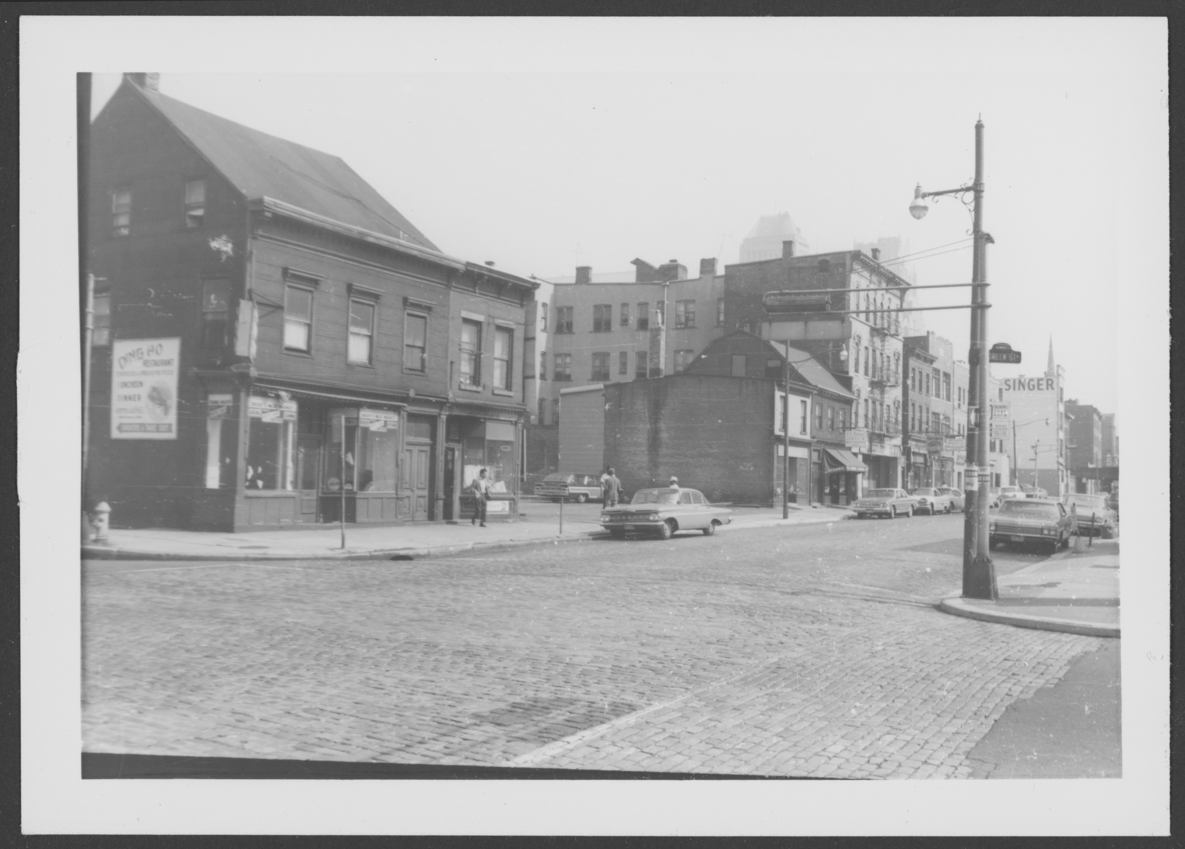


Search by street name, not address