• About
  • Contribute
  • A Project by Myles Zhang
Newark Changing
Newark Changing
Mapping neighborhood demolition: 1950s to today
 
Skip to content
  • Essays on urban decay
    • Neighborhood Maps
    • University Heights
    • Black and Blight
    • Interstate Highways (78 and 280)
    • The Rise and Fall of Downtown
    • Redlining & Manufactured Decline
    • Samuel Berg Interview + Bio
    • Urban Renewal by the Numbers
    • What does racializing space mean?
  • Featured Images with Memories

Author: Myles Zhang

No comments

E side Prince looking S from NW corner Morton

  By Myles Zhang May 1960 April 2026 Belmont, Demolished Buildings

Tagged   corner store, light pole, man crossing street, Nat's food shop, parked cars, row of buildings, traffic light
No comments

W side Charlton looking SW from NE corner Waverly is now the middle of this super block.

  By Myles Zhang May 1960 April 2026 Belmont, Demolished Buildings

Tagged   brick building, brick road, parked cars, row of buildings, trees, utility pole
No comments

W side Barclay looking SW from NE corner Waverly

  By Myles Zhang May 1960 April 2026 Belmont, Demolished Buildings

Tagged   billboard, gas station, parked cars, pig sign, row of houses, world's choice
No comments

N side Court looking E from SW corner Charlton

  By Myles Zhang May 1960 April 2026 Belmont, Demolished Buildings

Tagged   B Cooper furniture, corner store, furniture store, parked cars, row of buildings, street light
No comments

W side Rankin looking S from SE corner South Orange Ave is now the middle of this super block.

  By Myles Zhang May 1960 April 2026 Belmont, Demolished Buildings, South Orange Avenue

Tagged   brick road, fire escape, parked cars, row of buildings
No comments

NE corner South Orange & Hunterdon, Schaaf House, is now the campus of UMDNJ.

  By Myles Zhang May 1960 April 2026 Demolished Buildings, New Jersey College of Medicine and Dentistry, South Orange Avenue, University Heights

Tagged   asphalt street, corner house, fire hydrant, house with porch, parked cars, tree
No comments

E side Prince looking S from Springfield Ave

  By Myles Zhang May 1960 April 2026 Belmont, Demolished Buildings, Springfield Avenue

Tagged   awnings, bakery, fire escape, Lembroff's, parked cars, store front, Wiglers
No comments

S side Rose looking SW from NE corner Barclay is now the middle of this super block.

  By Myles Zhang May 1960 April 2026 Belmont, Demolished Buildings

Tagged   car, corner store, parked cars, row of houses, store front, trees
No comments

W side Somerset looking SW from NE corner Rose is now the middle of this super block.

  By Myles Zhang May 1960 April 2026 Belmont, Demolished Buildings

Tagged   fire hydrant, man standing, parked cars, row of houses, utility pole
No comments

W side Hill Place looking SW from NE corner Rose is now the middle of this super block.

  By Myles Zhang May 1960 April 2026 Belmont, Demolished Buildings

Tagged   parked cars, row of houses, trees
No comments

W side Avon Place looking SW from NE corner Waverly

  By Myles Zhang May 1960 April 2026 Belmont, Demolished Buildings

Tagged   fire hydrant, men walking, parked cars, row of buildings, tree, truck, utility pole
No comments

#62 Prince, E side, looking NE toward Springfield, Sidney’s Rest

  By Myles Zhang May 1960 April 2026 Belmont, Demolished Buildings, Springfield Avenue

Tagged   asphalt street, awnings, businesses, delicatessens, Hygrade's, liquor store, meat market, parked cars, store front
No comments

W side Howard St looking S from NE corner 12th Ave

  By Myles Zhang May 1960 April 2026 Demolished Buildings, University Heights

Tagged   bar, car, Fifty bar, fire hydrant, parked cars, traffic light, trees, utility pole
No comments

S side Waverly looking SW from NE corner Charlton

  By Myles Zhang May 1960 April 2026 Belmont, Demolished Buildings

Tagged   asphalt street, corner building, fire escape, parked cars
No comments

W side Prince looking N from SE corner Court

  By Myles Zhang May 1960 April 2026 Belmont, Demolished Buildings

Tagged   asphalt street, corner store, fire escape, have a pepsi sign, Kleinert's, liquor store, row of buildings, traffic light, utility pole
No comments

S side Rose looking SW from NE corner Somerset is now the middle of this super block.

  By Myles Zhang May 1960 April 2026 Belmont, Demolished Buildings

Tagged   asphalt street, parked cars, row of houses, trees, utility pole
No comments

S side Spruce looking SW from NE corner Charlton

  By Myles Zhang May 1960 April 2026 Belmont, Demolished Buildings

Tagged   Ben's, corner store, fire escape, meat market, parked cars, utility pole
No comments

S side Rose looking SW from NE corner Stratford Place is now the middle of this super block.

  By Myles Zhang May 1960 April 2026 Belmont, Demolished Buildings

Tagged   corner building, parked cars, trees, utility pole
No comments

W side Prince looking SW from NE corner Waverly

  By Myles Zhang May 1960 April 2026 Belmont, Demolished Buildings

Tagged   parked cars, row of buildings, row of cars, street sign, tree, utility poles
No comments

S side Rose looking SW from NE corner Hillside Place is now the middle of this super block.

  By Myles Zhang May 1960 April 2026 Belmont, Demolished Buildings

Tagged   asphalt street, corner building, fire escape, parked cars, people walking, tree
No comments

W side Broome looking S from SE corner South Orange Ave

  By Myles Zhang May 1960 April 2026 Belmont, Demolished Buildings, South Orange Avenue

Tagged   buildings, one way, parked cars, utility pole
No comments

W side Charlton looking SW from NE corner Spruce

  By Myles Zhang May 1960 April 2026 Belmont, Demolished Buildings

Tagged   corner store, esso, fire escape, gas station, market, parked cars, utility pole
No comments

W side Stratford Place looking SW from NE corner Rose is now the middle of this super block.

  By Myles Zhang May 1960 April 2026 Belmont, Demolished Buildings

Tagged   parked cars, row of cars, row of houses, trees, utility pole
No comments

Row house, #409 West Market (2nd from corner Fairmount)

  By Myles Zhang May 1960 April 2026 Demolished Buildings, Fairmount, Market Street

Tagged   asphalt street, multi level house, sidewalk, store front
No comments

W side Prince looking S from SE corner South Orange Ave

  By Myles Zhang May 1960 April 2026 Belmont, Demolished Buildings, South Orange Avenue

Tagged   asphalt street, fire escape, parked cars, row of buildings, sidewalk, trucks, utility pole
No comments

S side Waverly looking SW from NE corner Prince

  By Myles Zhang May 1960 April 2026 Belmont, Demolished Buildings

Tagged   corner building, fire hydrant, Leacrafts, one way, parked cars
No comments

N side Court looking E from SW corner Charlton is now the middle of this super block.

  By Myles Zhang May 1960 April 2026 Belmont, Demolished Buildings

Tagged   asphalt street, B Cooper furniture, corner store, fire escape, furniture store, keep right sign, parked cars, row of buildings, street light
No comments

E side Charlton looking N from SW corner Morton is now the middle of this super block.

  By Myles Zhang May 1960 April 2026 Belmont, Demolished Buildings

Tagged   asphalt street, parked cars, row of houses, street sign, utility pole
No comments

S side Waverly looking SW from NE corner Barclay

  By Myles Zhang May 1960 April 2026 Belmont, Demolished Buildings

Tagged   asphalt street, esso, fire hydrant, parked cars, service station
No comments

W side Barclay looking SW from NE corner Rose is now the middle of this super block.

  By Myles Zhang May 1960 April 2026 Belmont, Demolished Buildings

Tagged   one way, parked cars, row of houses, trees, utility pole
No comments

S side Waverly looking SW from NE corner Avon Place

  By Myles Zhang May 1960 April 2026 Belmont, Demolished Buildings

Tagged   corner store, parked cars, Quality market, row of buildings, utility pole
No comments

E side Prince looking S from NW corner Court

  By Myles Zhang May 1960 April 2026 Belmont, Demolished Buildings

Tagged   awnings, businesses, Hygrade, parked cars, Sidney's, Tobin's, Wiglers
No comments

Saint Michael’s Hospital looking NE from SW corner Central & High

  By Myles Zhang May 1960 April 2026 Central Avenue, James Street Commons, Preserved Buildings

Tagged   bus stop, church, hospital, lamp post, row of cars, street light
No comments

E side High looking NE from SW corner Bank, toward Academy, is now the campus of Essex County College.

  By Myles Zhang May 1960 April 2026 Demolished Buildings, Essex County College, University Heights

Tagged   auto center, brick street, cars, corner building, street lamp
No comments

Longworth St looking W from Washington St

  By Myles Zhang May 1960 April 2026 Demolished Buildings, Lincoln Park

Tagged   brick road, parked cars, row of houses, street light, trees
No comments

N side Central Ave looking W from SW corner Plane to Burnet is now a parking lot

  By Myles Zhang May 1960 April 2026 Central Avenue, Demolished Buildings, James Street Commons

Tagged   bus stop, frigadair, frigida, gold food, liquor store, Mount Carmel Guild, newark auto shop, store front
No comments

Nevada St looking N from Marshall St to Court St

  By Myles Zhang May 1960 April 2026 Demolished Buildings, Downtown

Tagged   asphalt street, brick building, fire escape, one way
No comments

#562 High St, Dr. Edwin Seidman House, is now Arts High School

  By Myles Zhang May 1960 April 2026 Belmont, Demolished Buildings, Downtown, High Street

Tagged   asphalt street, house with chimney, school, street parked cars, three story house, trees
No comments

W side High St looking SW from opposite Mercer

  By Myles Zhang May 1960 April 2026 Belmont, High Street, Street Scenes of Partial Demolition

Tagged   apartment building, asphalt stree, bushes, cars, corner building, trees
No comments

E side High St looking NE from SW corner Summit Place is now the campus of Rutgers University.

  By Myles Zhang May 1960 April 2026 Demolished Buildings, High Street, Rutgers University

Tagged   cars, meter parking, row of houses, street lamp, street sign
No comments

E side High St looking NE from SW corner Bleeker is now the campus of Rutgers University.

  By Myles Zhang May 1960 April 2026 Demolished Buildings, Downtown, High Street, James Street Commons, Rutgers University

Tagged   brick street, fire hydrant, house building, row of cars, tree
No comments

#6-20 Longworth St, N side, from #31, looking E

  By Myles Zhang May 1960 April 2026 Demolished Buildings, Lincoln Park

Tagged   fire hydrant, parked cars, row of houses, sidewalk, trees
No comments

W side High St looking SW from NE corner William, toward Mercer

  By Myles Zhang May 1960 April 2026 Belmont, High Street, Street Scenes of Partial Demolition

Tagged   Finders, one way, spiked metal fence, street sign, traffic light
No comments

N side Marshall looking N from SW corner Broad at corner building

  By Myles Zhang May 1960 April 2026 Broad Street, Demolished Buildings, Downtown

Tagged   corner store, fire escape, Formula B-7 sign, Gulf sign, parked cars, S&H green stamps, sidewalk
No comments

N side Marshall looking E from SW corner Broad is now the middle of this super block.

  By Myles Zhang May 1960 April 2026 Broad Street, Demolished Buildings, Downtown

Tagged   building, no parking sign, parked cars, private property, street light
No comments

E High St looking NE from SW corner New St is now the campus of Rutgers University.

  By Myles Zhang May 1960 April 2026 Demolished Buildings, Downtown, High Street, Rutgers University

Tagged   church, Gonzalez cafe, no right turn, one way, row of cars, street corner, street light
No comments

Crawford St looking E from #53

  By Myles Zhang May 1960 April 2026 Demolished Buildings, Lincoln Park

Tagged   brick road, parked cars, row of buildings, row of cars, tree, utility pole
No comments

Longworth St looking E from High St

  By Myles Zhang May 1960 April 2026 High Street, Lincoln Park, Preserved Buildings

Tagged   brick road, buildings, downhill, parked cars, tall building, trees, utility pole
No comments

SE corner Warren & High St from NW corner is now the campus of Rutgers University.

  By Myles Zhang May 1960 April 2026 Downtown, High Street, Rutgers University, Street Scenes of Partial Demolition

Tagged   building, fire hydrant, parking lot, street light, trash can
No comments

Coe’s Place Public School on E side Coe’s Place

  By Myles Zhang May 1960 April 2026 Demolished Buildings, Downtown

Tagged   american flag, asphalt street, lamp post, public school, school
«‹4546474849›»
  • You found an easter egg!

    Browse all photos on map

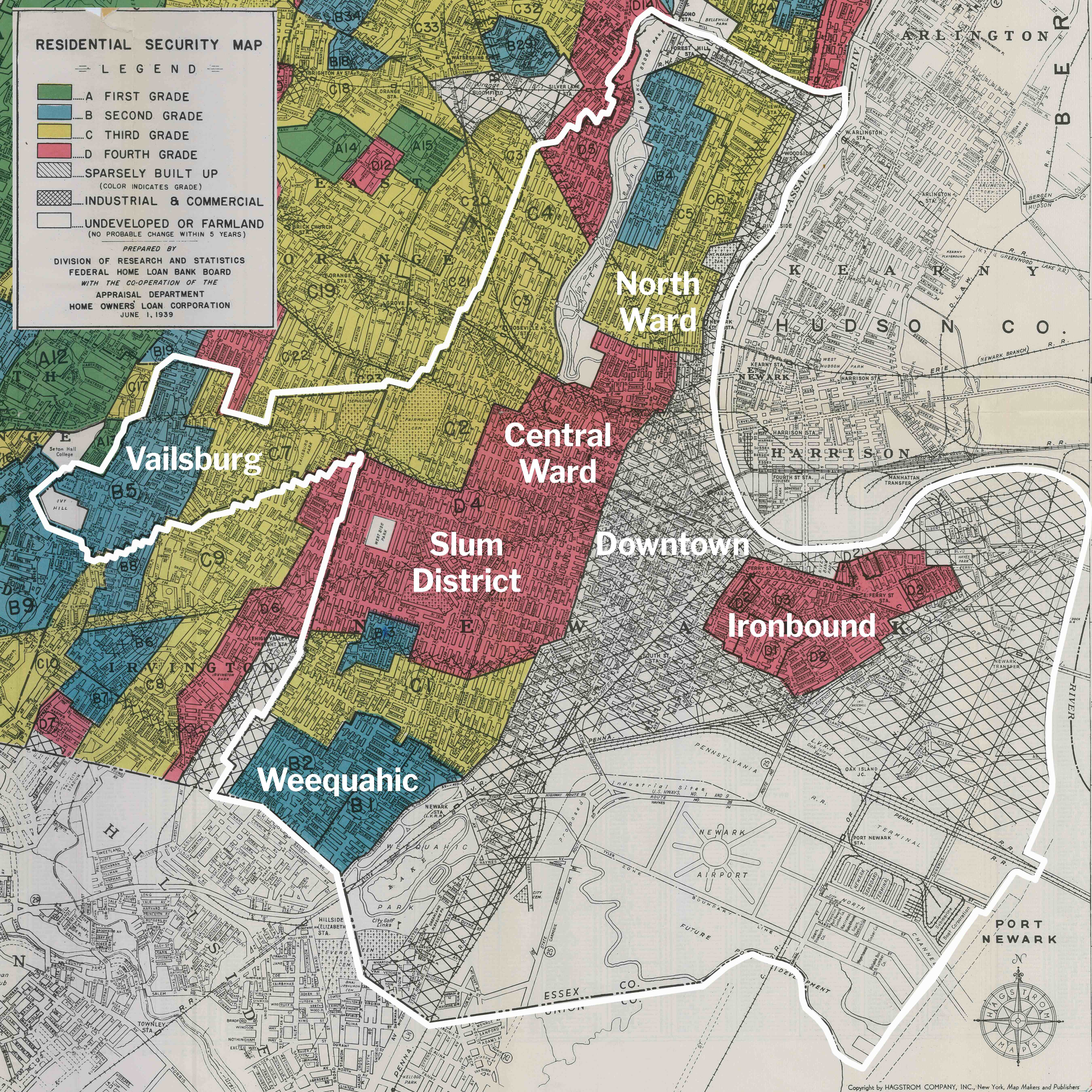
    ^1939 redlining map. What is redlining?

    Search by street name, not address


    Is this a photo of the home you lost or a place you know?
    Leave a comment with your memories.


    Project lead: Myles Zhang
    Research method, credits,
    and notes on naming conventions
  • Browse by slum clearance project

    • Redlining & Manufactured Decline
    • New Jersey College of Medicine and Dentistry
    • Newark College of Engineering
    • Rutgers University
    • Essex County College
    • Gateway Center
    • Interstate 78
    • Interstate 280
    • .
    • How many people were displaced?
    • How much did this cost taxpayers?
  • Browse by neighborhood

    • CENTRAL WARD
      • Belmont
      • Downtown
      • Four Corners
      • James Street Commons
      • Lincoln Park
      • Military Park
      • South Broad Street
      • University Heights
        • .
    • OTHER WARDS
      • Clinton Hill
      • Fairmount
      • Forest Hill / Upper Broadway
      • Ironbound
      • Roseville
      • Seventh Ave / Lower Broadway
      • Upper Roseville
      • Weequahic
  • Browse by significant street

    • Broad Street
    • Central Avenue
    • High Street
    • James Street
    • Market Street
    • McCarter Highway
    • Orange Street
    • South Orange Avenue
    • Springfield Avenue
  • Browse by status of preservation or demolition

    • Preserved Buildings
    • Street Scenes of Partial Demolition
    • Demolished Buildings
  • Browse by subject

    abandoned building american flag apartment building asphalt street auto shop awning baptist church bar barbershop bare tree bare trees bay window billboard billboards branch brook park brick road building buildings bushes car cars child children church cleaners coca cola sign commercial building corner building corner house corner store cross do not enter drugstore empty lot esso factory fence fire escape fire hydrant food market for rent furniture store garage gas station grocery store house jordan baris laundry liquor store lot luncheonette manhole cover man standing man walking men standing men walking multi level building multi level house no left turn no parking no right turn one way parked cars parking lot people standing people walking pepsi pepsi sign phonebooth picket fence porch post office mailbox railroad tracks restaurant row of buildings row of businesses row of cars row of houses row of trees Schenley school sidewalk store front street light street parked car street parked cars street sign sunoco tavern traffic light trash can trash cans tree trees truck utility pole utility poles woman walking women walking wooden fence

  • Noticed a mistake?

    All photos were manually referenced to their contemporary locations. Contemporary street views correspond to camera angles of former photos, even though address naming conventions and house numbers may have changed.
    If a photo is misplaced, contact mylesz@umich.edu with a link to the photo and description of the error.

Samuel Berg's photos are copyrighted by the Newark Public Library and must be credited to the library. Commercial uses require service fees. Contact: http://npl.org/copies/
Powered by Parabola & WordPress.